| Content from Wikipedia under the CC BY-SA 4.0 license ⇔ Maps from OpenStreetMap under the ODbL license |
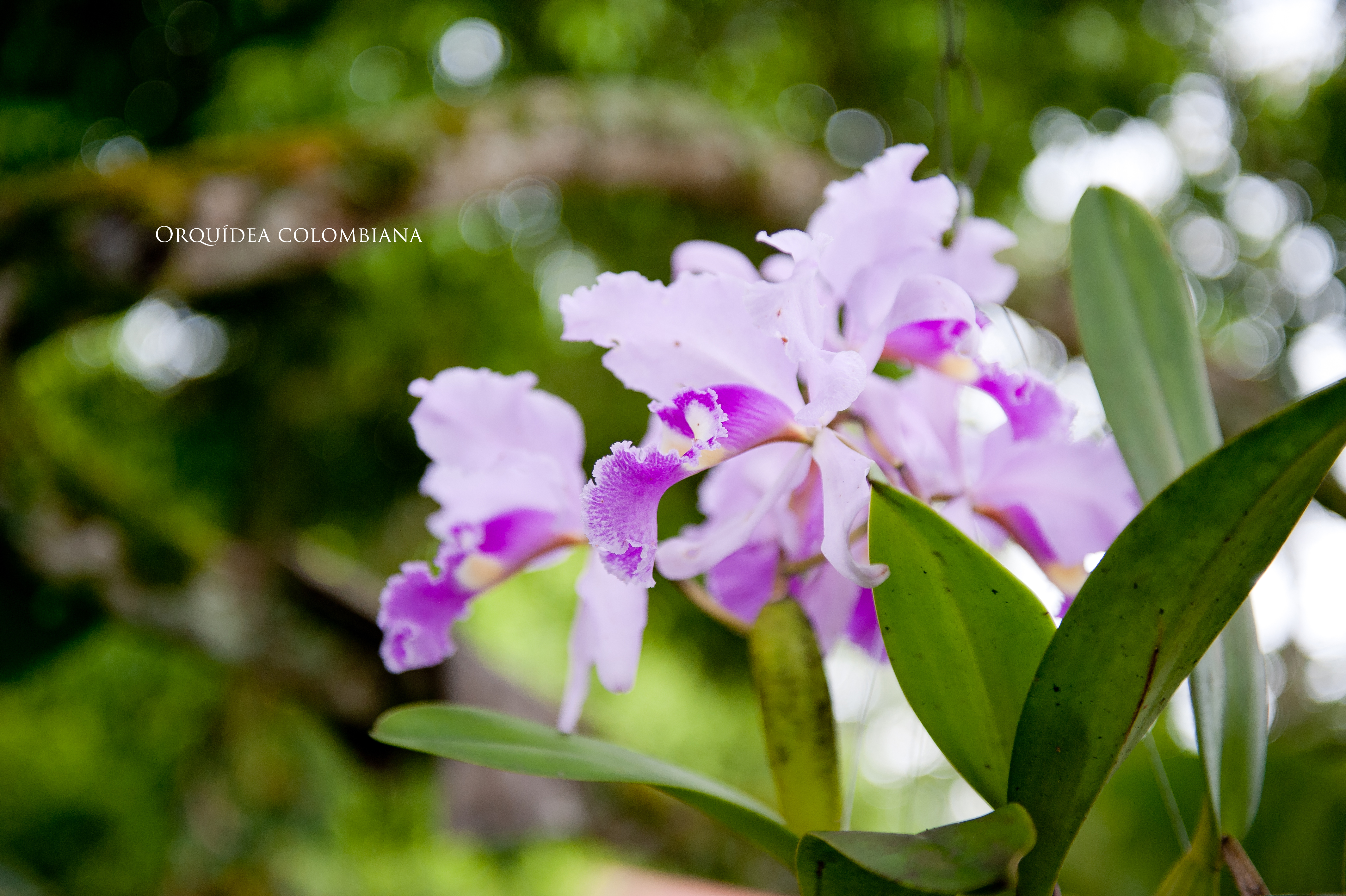
File:Cattleya trianae, Flor Nacional de Colombia.jpg
From Hispanopedia
Original file (4,256 × 2,832 pixels, file size: 7.76 MB, MIME type: image/jpeg)
This file is from Wikimedia Commons and may be used by other projects. The description on its file description page there is shown below.
Summary
| DescriptionCattleya trianae, Flor Nacional de Colombia.jpg |
Español: Flor Nacional de Colombia |
| Date | |
| Source | https://www.flickr.com/photos/mario_carvajal/5565979299/ |
| Author | Mario Carvajal |
| Camera location | 4° 29′ 29.62″ N, 75° 41′ 11.45″ W | View this and other nearby images on: OpenStreetMap |
|---|
Licensing
| This image was originally posted to Flickr by Mario Carvajal at https://www.flickr.com/photos/22134952@N04/5565979299. It was reviewed on 2013-07-22 17:50:43 by FlickreviewR, who found it to be licensed under the terms of the cc-by-2.0, which is compatible with the Commons. It is, however, not the same license as specified on upload, which was the cc-by-sa-2.0, and it is unknown whether that license ever was valid. |
This file is licensed under the Creative Commons Attribution 2.0 Generic license.
- You are free:
- to share – to copy, distribute and transmit the work
- to remix – to adapt the work
- Under the following conditions:
- attribution – You must give appropriate credit, provide a link to the license, and indicate if changes were made. You may do so in any reasonable manner, but not in any way that suggests the licensor endorses you or your use.
Captions
Add a one-line explanation of what this file represents
Items portrayed in this file
depicts
some value
4°29'29.61600"N, 75°41'11.44799"W
26 March 2011
image/jpeg
0.00125 second
2.8
52 millimetre
400
18949c4a514cd72d250826bdbb6031661d5c79ee
8,135,040 byte
2,832 pixel
4,256 pixel
File history
Click on a date/time to view the file as it appeared at that time.
| Date/Time | Thumbnail | Dimensions | User | Comment | |
|---|---|---|---|---|---|
| current | 19:03, 22 July 2013 | No thumbnail | 4,256 × 2,832 (7.76 MB) | wikimediacommons>Jimysantandef | User created page with UploadWizard |
File usage
The following page uses this file:
Metadata
This file contains additional information, probably added from the digital camera or scanner used to create or digitize it.
If the file has been modified from its original state, some details may not fully reflect the modified file.
| Image title |
|
|---|---|
| Camera manufacturer | NIKON CORPORATION |
| Camera model | NIKON D700 |
| Author | Mario Carvajal |
| Copyright holder |
|
| Exposure time | 1/800 sec (0.00125) |
| F Number | f/2.8 |
| ISO speed rating | 400 |
| Date and time of data generation | 12:05, 26 March 2011 |
| Lens focal length | 52 mm |
| Latitude | 4° 29′ 29.62″ N |
| Longitude | 75° 41′ 11.45″ W |
| Altitude | 1,471 meters above sea level |
| Online copyright statement | www.mariocarvajal.com |
| Short title |
|
| City shown | Calarcá |
| Width | 4,256 px |
| Height | 2,832 px |
| Bits per component |
|
| Pixel composition | RGB |
| Orientation | Normal |
| Number of components | 3 |
| Horizontal resolution | 240 dpi |
| Vertical resolution | 240 dpi |
| Software used | Adobe Photoshop CS5 Macintosh |
| File change date and time | 20:21, 27 March 2011 |
| Exposure Program | Normal program |
| Exif version | 2.21 |
| Date and time of digitizing | 12:05, 26 March 2011 |
| APEX shutter speed | 9.643856 |
| APEX aperture | 2.970854 |
| APEX exposure bias | 0 |
| Maximum land aperture | 3 APEX (f/2.83) |
| Subject distance | 0.71 meters |
| Metering mode | Pattern |
| Light source | Unknown |
| Flash | Flash did not fire |
| DateTimeOriginal subseconds | 33 |
| DateTimeDigitized subseconds | 33 |
| Color space | sRGB |
| Sensing method | One-chip color area sensor |
| File source | Digital still camera |
| Scene type | A directly photographed image |
| Custom image processing | Normal process |
| Exposure mode | Auto exposure |
| White balance | Auto white balance |
| Digital zoom ratio | 1 |
| Focal length in 35 mm film | 52 mm |
| Scene capture type | Standard |
| Scene control | Low gain up |
| Contrast | Normal |
| Saturation | Normal |
| Sharpness | Normal |
| Subject distance range | Unknown |
| GPS time (atomic clock) | 17:05 |
| Satellites used for measurement | 06 |
| Geodetic survey data used | WGS 84 |
| GPS date | 26 March 2011 |
| GPS tag version | 0.0.2.2 |
| Serial number of camera | 2386763 |
| Lens used | 24.0-70.0 mm f/2.8 |
| Date metadata was last modified | 15:21, 27 March 2011 |
| Copyright status | Copyrighted |
| Unique ID of original document | xmp.did:8FDBA2B80F206811BA03B827ABBA00FE |
| Contact information | mario@mariocarvajal.com
www.mariocarvajal.com Diagonal 27 3A-03 Ap.308, San Diego 2 Bogotá, Cundinamarca, 110311 Colombia |
| Keywords |
|
| Sublocation of city shown | Hacienda Combia |
| Province or state shown | Quindío |
| Country shown | Colombia |
| IIM version | 2 |