| Content from Wikipedia under the CC BY-SA 4.0 license ⇔ Maps from OpenStreetMap under the ODbL license |
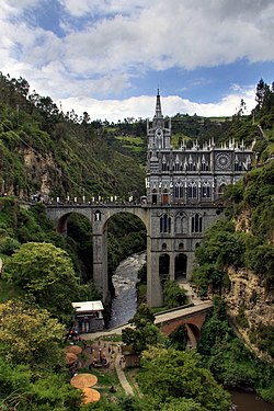
File:52 - Ipiales - Décembre 2008.jpg

Summary
| Description |
Français : Le Sanctuaire de Las Lajas, Colombie
English: Las Lajas Cathedral, Colombia
Español: La catedral de Las Lajas (Colombia)
Gaeilge: An Ardeaglais na Las Lajas, an Cholóim
Italiano: Santuario di Las Lajas, Colombia
Português: A catedral de Las Lajas, Colômbia |
||
| Date | |||
| Source | Own work | ||
| Author | Martin St-Amant (S23678) | ||
| Permission (Reusing this file) |
|


| Camera location |  | View this and other nearby images on: OpenStreetMap |  |
|---|
Licensing


- You are free:
- to share – to copy, distribute and transmit the work
- to remix – to adapt the work
- Under the following conditions:
- attribution – You must give appropriate credit, provide a link to the license, and indicate if changes were made. You may do so in any reasonable manner, but not in any way that suggests the licensor endorses you or your use.
- share alike – If you remix, transform, or build upon the material, you must distribute your contributions under the same or compatible license as the original.
File history
Click on a date/time to view the file as it appeared at that time.
| Date/Time | Thumbnail | Dimensions | User | Comment | |
|---|---|---|---|---|---|
| current | 01:19, 15 August 2022 | | 3,008 × 4,512 (4.57 MB) | wikimediacommons>User-duck | Cropped 2x3 using CropTool with lossless mode. |
File usage
The following page uses this file: