| Content from Wikipedia under the CC BY-SA 4.0 license ⇔ Maps from OpenStreetMap under the ODbL license |
File:Spanish mediterranean 1519.jpg
From Hispanopedia
Size of this preview: 800 × 497 pixels. Other resolutions: 320 × 199 pixels | 640 × 397 pixels | 1,024 × 636 pixels | 1,280 × 795 pixels | 1,777 × 1,103 pixels.
Original file (1,777 × 1,103 pixels, file size: 1.03 MB, MIME type: image/jpeg)
Summary
| Description |
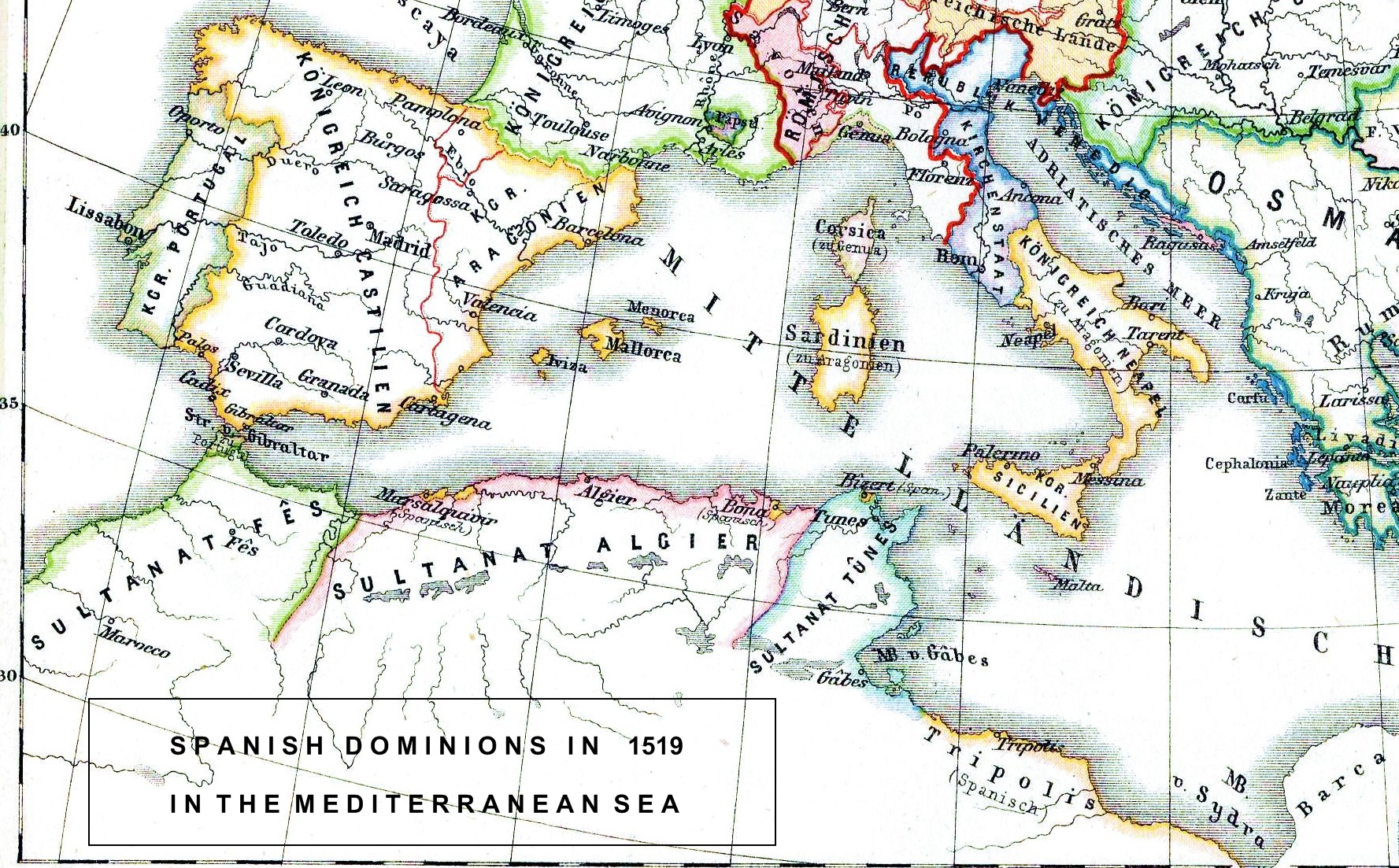
Español: Mapa de los dominios de España en 1519 en el mar Mediterráneo. En amarillo se aprecian las posesiones españolas en el norte de África (junto con Tánger –en verde– perteneciente a Portugal): Orán (Marsalquivir), Bona, Bizerta, Túnez y Tripolitania. Imagen tomada de una sección de un mapa de Wikicommons, File:Europa 1519.JPG, al que le he agregado datos con mi software. English: Spanish Mediterranean dominions in 1519 (yellow) |
| Date | |
| Source | Own work |
| Author | MassimoCanepari |
Licensing
I, the copyright holder of this work, hereby publish it under the following license:


This file is licensed under the Creative Commons Attribution-Share Alike 3.0 Unported license.
- You are free:
- to share – to copy, distribute and transmit the work
- to remix – to adapt the work
- Under the following conditions:
- attribution – You must give appropriate credit, provide a link to the license, and indicate if changes were made. You may do so in any reasonable manner, but not in any way that suggests the licensor endorses you or your use.
- share alike – If you remix, transform, or build upon the material, you must distribute your contributions under the same or compatible license as the original.
File history
Click on a date/time to view the file as it appeared at that time.
| Date/Time | Thumbnail | Dimensions | User | Comment | |
|---|---|---|---|---|---|
| current | 03:44, 8 October 2012 | | 1,777 × 1,103 (1.03 MB) | wikimediacommons>MassimoCanepari | User created page with UploadWizard |
File usage
The following page uses this file:


