| Content from Wikipedia under the CC BY-SA 4.0 license ⇔ Maps from OpenStreetMap under the ODbL license |
File:Castellano-Español-es.png
From Hispanopedia

Size of this preview: 451 × 599 pixels. Other resolutions: 181 × 240 pixels | 521 × 692 pixels.
Original file (521 × 692 pixels, file size: 47 KB, MIME type: image/png)

|
This linguistic map image could be re-created using vector graphics as a SVG file. This has several advantages; see Commons:Media for cleanup for more information. If a SVG form of this image is available, please upload it and afterwards replace this template with
{{vector version available|new image name}}.It is recommended to name the SVG file “Castellano-Español-es.svg”—then the template Vector version available (or Vva) does not need the new image name parameter. |
Summary
| Description |
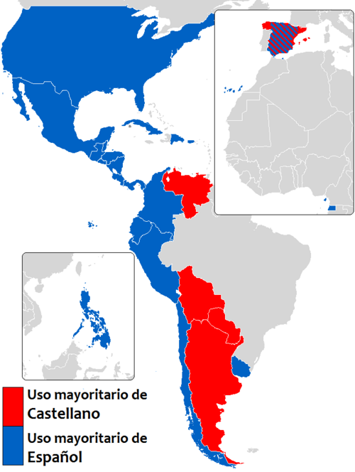
English: Most commonly used names given to the Spanish Language (the term for "Spanish" is in blue and "Castilian" is in red)
Español: Los términos de mayor uso para referirse al idioma español ("español" en azul y "castellano" en rojo)
Italiano: Termini di uso più comune in riferimento alla lingua spagnola (Spagnolo)
Türkçe: İspanyolca' ya dünyada verilen isimler (İspanyolca) |
| Date | |
| Source | English Wikipedia en:Image:Castellano-Español.png |
| Author | User:Bnwwf91 made this photo to show the difference in the names given to the Spanish Language |
| Permission (Reusing this file) |
Released to public domain |
Licensing

|
This work has been released into the public domain by its author, Bnwwf91 at English Wikipedia. This applies worldwide. In some countries this may not be legally possible; if so: Bnwwf91 grants anyone the right to use this work for any purpose, without any conditions, unless such conditions are required by law. |
File history
Click on a date/time to view the file as it appeared at that time.
| Date/Time | Thumbnail | Dimensions | User | Comment | |
|---|---|---|---|---|---|
| current | 18:36, 11 February 2026 | | 521 × 692 (47 KB) | wikimediacommons>Sky Harbor | Reverted to version as of 19:13, 19 October 2025 (UTC). Once again, there is no consensus to remove Israel, Western Sahara and the Philippines, nor did the user in question try to get consensus either on the English or Spanish Wikipedias. Furthermore, the map is a linguistic map, not a political one, so it shouldn't matter if the language is official or not; they are territories where the language is spoken. |
File usage
The following page uses this file: